KCDC OPEN HOUSE

Open House Poster 3.png

The KCDC will be hosting its virtual Open House/Public Presentation for the Kansas City, Kansas Study on December 10th. There will be two different online sessions that you can choose from depending on your availability. Please see below for times and details. For more information on the project visit our project page .

Open House Session 1
Thursday, December 10th 12-1:30pm
Registration Link: https://us02web.zoom.us/meeting/register/tZYtcOiupj0qGt2hrXe0LNlxX6OjVJhNI62T
*Please register by 11:00am

Open House Session 2
Thursday December 10th 4:00pm-5:30pm
Registration Link: https://us02web.zoom.us/meeting/register/tZUlcuCtqzMoH9RGaLYBZK0XO3bhjl-Cl2d_
*Please register by 3:00pm

PROGRAM:
Project Introduction/Overview presentation (20 min)
Q&A (10min)

Group 1/Kaw point area presentation (20 min)
Q&A (10 min)

Group 2/Armourdale area presentation (20 min)
Q&A (10 min)

Reach out to KCDC Executive Assistant, Mariah Randell (mrandell@kcdesigncenter.org) with any questions.
Moving Towards the Concept

Following our second advisory meeting and the insightful feedback we received, the studio has been gearing up for the second professional review. As stated in our last post, we have focused on refining our Vision, Mission and Goals statement, as well as formulating our conceptual design framework and conclusions. As we have proceeded with our research and conclusions, both inventory and analytical as well as cross-maps, our programming has also taken a second step towards the outline and layout of content.

Based on our conclusions from the inventory and analytical maps and cross maps, we determined that green infrastructure improvements to help the environmental conditions, potential sites for interacting with the levee trail, and potential areas for public realm development are some of the key topics that will influence our masterplan. These findings led us to organize our maps around causes, effects, and opportunities on our site. By doing so, we were able to take a first pass at creating our conceptual diagrams.

We then focused and zoomed in to the potential areas within and around our site for green infrastructure, public realm, and connectivity opportunities. First, by cross mapping some of our environmental findings, we began to see where potential opportunities are. From there, we created a rating system to help us narrow down the most suitable sites for these green infrastructure and public realm opportunities.

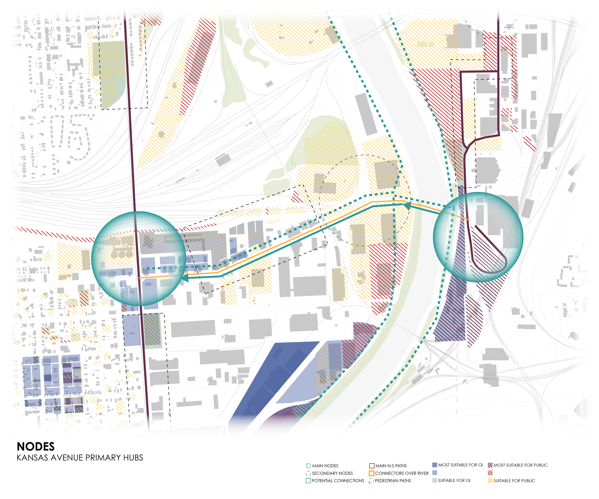
Then, we identified overall connectivity nodes from Kaw Point along the river down to Armourdale, and along 7th St. Taking a closer look at these nodes informed us of major streets that could become accessible for potential hubs and corridors of connectivity. Lastly, we were able to zoom in to nodes along James Street, Central Ave, and Kansas Ave. Our next steps are to further research these areas along the three major connectivity streets to better understand how to proceed with the framework and our concept.

This past Friday we had the opportunity to present all of our findings as well as exciting new research, conclusions, and a more refined vision, mission, and goals statement during our second professional review. We would like to support the below individuals for joining us and providing critical feedback, insight, and support so we can move the project forward.

Aaron Ross; Hoerr Schaudt, Principal
Gunnar Hand; Unified Gov of Wyandotte County, Director of Planning and Urban Design
James Pfeiffer; BNIM, Principal
Ryan Gedney; HNTB, Director
Tom Proebstle; Generator Studio, Co-Founder & Director
Vincent Cunnigan; Burns & McDonnell, Project Manager, NOMA KC
Derek Hoetmer; HOET, Co-Founder & Principal

Now, with the input and push from our wonderful critics, the studio is working to polish our conceptual diagrams, further research into the social and cultural life of Strawberry Hill, Armourdale, and the Central Industrial District, and looking forward to a concrete concept. Tune in for more exciting updates!

KCDC Recruitment Meetings

images 1 smaller.png

The KCDC will be holding two info sessions for K-State students interested in joining the program. If you are interested in urban design and working on a community-based project in downtown Kansas City, join the Kansas City Design Center on Monday, November 2nd, or Thursday November 5th on zoom to learn about the exciting opportunity to take your final studio at KCDC and work on engaging interdisciplinary projects that make a difference. Info session times and registration links are below. Reach out to Mariah at mrandell@kcdesigncenter.org with any questions you may have!

Monday, November 2nd @ 5:30pm session registration link: (note: registration will close at 5:00pm) https://us02web.zoom.us/meeting/register/tZEpdOqprz4iE9br4m665pLn3NFrsoWqCQwE

Thursday, November 5th @ 12:30pm session registration link: https://us02web.zoom.us/meeting/register/tZEsd-6vpzMqG9Z-nB03nac5Vn70F-rNFr1M

The Studio Develops the Project Vision, Mission & Goals

We started our 8th week of classes with our first professional review. In the midst of virtual learning, we decided to present using google slides to prevent lag time over zoom. As a studio, we have continually been exploring new platforms that are the most efficient for virtual learning. We presented all of our findings during the review which included inventory, cross mapping, analysis, case studies, and our first pass at the vision and mission statement. After receiving strong feedback on how to move forward, we feel confident in our approach.

Screen Shot 2020-10-23 at 11.17.25 AM.png

Our main focus is now revising our Vision & Mission statement, which means making it more structured and relevant without being too specific to allow for some flexibility as we continue the project. We also developed more project specific goals for our site, such as Industrial goals, public realm goals, and ecological goals. Although it is not finalized, we feel like we are pushing these ideas in the right direction.

Screen Shot 2020-10-23 at 11.18.55 AM.png

As we mentioned in past blog posts, a big portion of our mapping is cross mapping, which is when you compare 2 or more maps to develop a new conclusion from the overlaid information. So far, we have only overlaid our inventory maps. After our review, we decided that it was important to also include our analytical maps. Some of the topics we are looking into are: how to reduce stormwater runoff by looking at areas of flooding and the lowest topographical areas on the maps, the comparison of private investment areas with future plans of the city, looking at the levee trail environmental conditions, potential sites for access to the levee trail, and how to mediate brownfield pollution. By comparing our analytical maps with some of our maps from inventory, we can draw conclusions about our site that will influence our overall masterplan when we get to that point.

LOW POINTS & GREEN INFRASTRUCTURE-01.jpg
Flooding v. Brownfields-01.jpg

The other exciting development in studio is that we are starting to lay out the programming book. This book will include all of our work and findings for the entire semester. The first step towards its creation is outlining our information and cutting out whatever is not relevant. There are a few different approaches to do this— first, we could completely eliminate maps that we feel do not pertain to the overall goals. Alternatively, we could use those maps for cross mapping and try to draw conclusions from them that would ultimately help us meet our goals. I think that in the end, there will be a mixture of these strategies as we have over 300 maps and are still producing more. We are excited to see how the project continues to develop… happy midterms!

Inventory & Analysis of KCK

As you know from our last post, we have been doing extensive inventory mapping. One of the latest discoveries has been Commuter Travel information in and out of our site. The graphics and data below present these findings at our 3 different site scales. This information was a great asset to our compilation of research and is just one of the many supporting sets of data that we will refer to as we continue in the next phase of Analysis. 

After collecting these inventory maps, we were able to cross map all of our findings. When overlaid with each other and in different combinations we came across four main themes: patterns of the city and it’s disconnection, identity of the city, vacancy and river access and the potential relationships, and quality of life.

We were able to present all these findings this past Friday in our first presentation to our Project Advisory Group!  We would like to thank the following for attending and providing feedback, additional insight, and continued resources:

Troy Shaw                     UG Public Works
Monica Mendez            UG Parks & Rec, Exec Director Armourdale Renewal Assoc
Angel Obert                  UG Parks & Rec, Assistant Director
Bill Wilhite                    Premier Investments
Kim Portillo                  UG Planning Dept.
Thomas Meyer              Americor Member & KSU RCP Grad
Blake Hensely               UG Health Dept
Bruce Holloway             Historic West Bottoms, Board Member
Scott Brown                  Historic West Bottoms, Board Member
Tom Jacobs                   Mid America Regional Council
Scott Mensing               Army Corps of Engineers, Program Manager

Zoom_Presentation w Advisory Board.PNG
Image (5).jpeg

One of our advisory members also informed us of a neighborhood meeting for the Armourdale area that will take place later this month.  We look forward to attending and asking the residents questions about their priorities and concerns for the area.  It will be a great opportunity to engage with the community in which we are designing for.

Now that we are deep into the second phase of our project, the analytical phase, we have a variety of maps that begin to show our findings of Environmental and Physical factors.  This has been everything from ground cover, heat islands, and pollution, to river front accessibility, significant spaces, and disconnections.  We are continuing to develop this collection of analytical maps as well as a few additional ones as suggested by our Advisory group members, such as homelessness, wildlife, hydrodynamics, and even smell mapping! Stay tuned to see more of our findings.

As you may have seen on our Instagram, we utilize Conceptboard as a primary source of collaboration during these times of mixed placement and remote working within the studio.  It has worked very well for us and is great for storyboarding, review and markups, and just day to day “pin-up” presentations or discussions!  Be sure to keep following along with our stories to see more behind the scenes of our process.  (@kcdesigncenter)

Concept Board 1.png